As Scotland’s Garden and Landscape Heritage (SGLH) Chairman I am very proud to present this story about Zetland Park by Iain Kirkman, volunteer on the Glorious Gardens team assigned by SGLH to the recording of non-inventory designed landscapes and gardens in the Falkirk area. The Glorious Gardens project was launched in Falkirk in 2015 and was funded by Historic Environment Scotland. This is one of the 16 sites covered by SGLH in this area. A similar project was carried out in the Clyde and Avon Valley, and we are currently planning a third phase, which will focus on sites in East Lothian. For more details, please go to https://www.sglh.org.
“Today, the public park is arguably the last bastion of the Victorian commitment to cultivate public good within the public realm.” (Historian Dr Katy Layton-Jones)
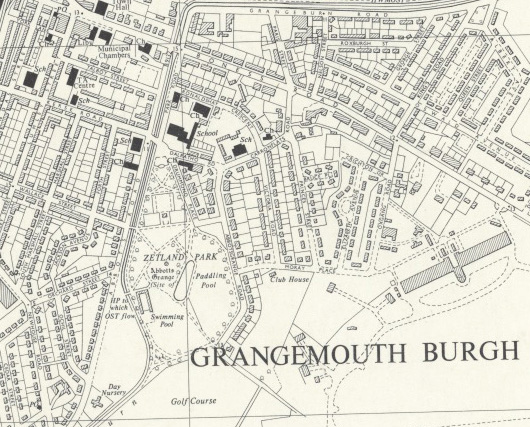
Zetland Park, in Grangemouth, is an impressive example of the nineteenth century Victorian parks movement. The park has been a witness to the life of Grangemouth since 1882. Over the years, it has hosted civic ceremonies, festive celebrations and diverse public recreation. Today it is the focus of an enthusiastic, community-driven regeneration project, led by the Friends of Zetland Park in collaboration with Falkirk Council and the National Lottery Heritage Fund. The area covered by the park has been known by several names since its first mention as Kars (Kerse) in the 12th century; the most recent – Zetland – results from the gift of the land for a public park by the Earl of Zetland in 1882.
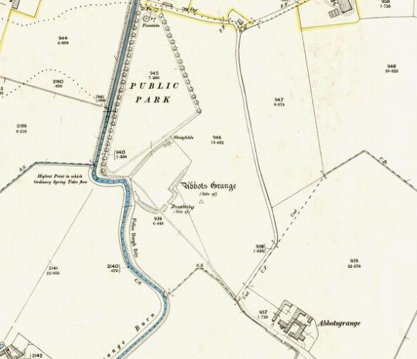
Abbott's Grange
Zetland Park lies within what was once the medieval barony and estate of Kerse. The present-day park includes a tree-encircled area, long known locally as “the Orchard.” This was the site of The Grange, a farming estate run from 1233 by the monks of Holyrood Abbey. The Grange gave its name to the adjacent Grange Burn and – eventually – to Grangemouth. It was conveniently situated near the burn’s tidal limit, which enabled grain to be shipped by boat via the rivers Carron and Forth to the monks’ mother house at Holyrood.
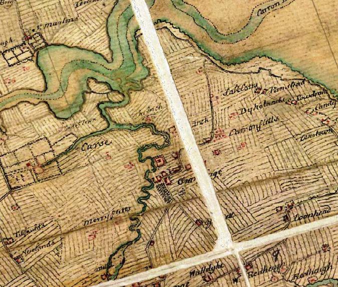
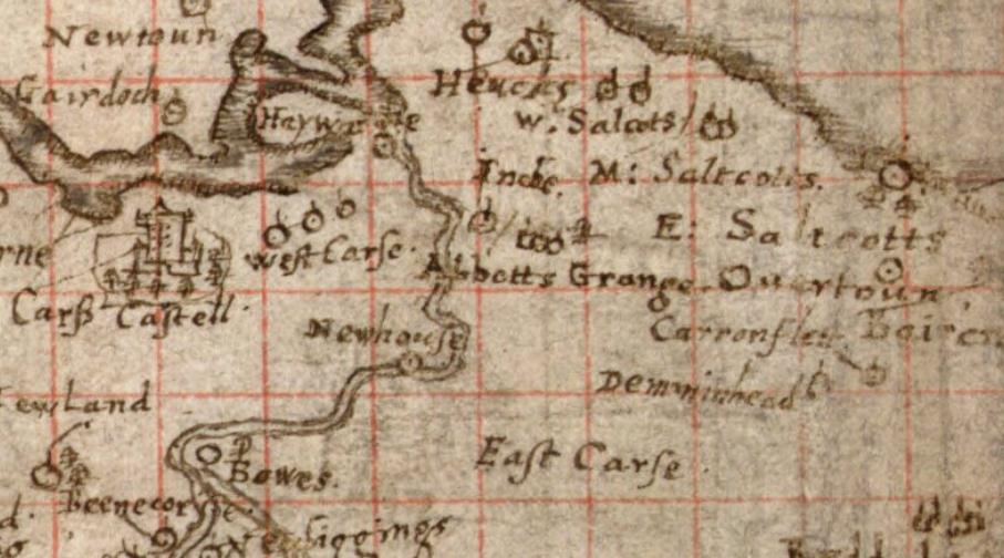
The Pont map shows Abbots Grange as a single site with one detached building and, to the south-east, three smaller structures, possibly housing for the farm workers and a granary or warehouse. To the west is the barony tower house, “Carse Castell.” In 2016, the orchard site was the object of a community archaeology excavation, led by AOC Archaeology for the Inner Forth Landscape Initiative. During the excavation the presence of a moated structure was confirmed. Fragments of medieval pottery were found and, towards the centre of the site, fallen stonework which may have been a granary or tower.
The Medieval Farming Landscape
Some two hundred years afer the Pont map, the Roy military map shows a substantial farmstead in a busy landscape of medieval “ridge and furrow” (an open-field system known as “runrig”). The settlement shown by the Pont map has grown, comprising a sizable house/enclosure and, to its south-east, a larger group of buildings (possibly grain stores and farm worker housing). The “Carse Castell” grounds (labelled “Carse”) are much larger than in Pont's time.
Eighteenth Century Improvements
From the 14th century onwards, many church estates were rented out or sold, and the Kerse estate had several owners. Sir Lawrence Dundas, later 1st Baronet of Kerse, bought it in 1752. In July 1768, Dundas cut the first turf at the eastern end of the Forth-Clyde Canal and later founded the port and the planned township of Grangemouth. Produce from his estate could now be transported by boat directly to Glasgow and Edinburgh.
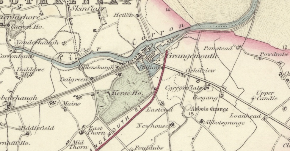
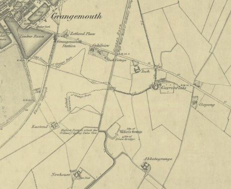
The c.1874 Ordnance Survey map (below) shows the new township of Grangemouth and both the “Orchard” and Abbots Grange Farm to its south-east. The Grange Burn has been straightened and canalised to the north of the orchard to connect with the Forth-Clyde Canal.
The First Park
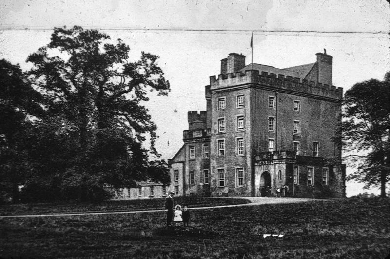
Generations of the Dundas family were involved in the development of Grangemouth before it became a Magistrate’s Burgh in 1872. In 1882, Lawrence Dundas, the Third Earl of Zetland (also the local member of parliament) donated part of the Kerse estate to the burgh for use as a public park. Zetland is an early form of “Shetland,” a name associated with the Dundas family and Grangemouth since the 1st Baronet’s grandson was created Earl of Zetland by Queen Victoria in 1838. The original donation is the triangular piece of land shown on the 1860 ordnance survey map above, which now forms the north section of the park. The southern and eastern fields were part of Abbotsgrange (now one word) farm.
The Inter-war Years
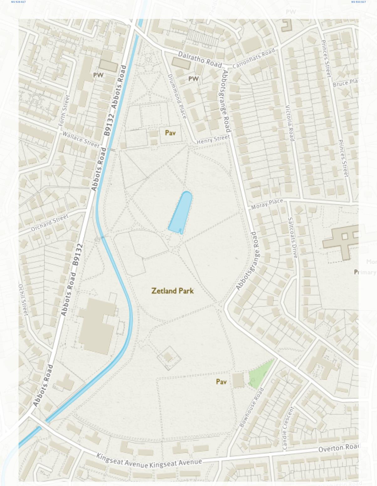
When World War One ended, a committee was set up to oversee the building of a war memorial for Grangemouth. In 1921 the Falkirk Herald paraphrased one of its members for whom the park “was not a thing of beauty (laughter).” It “was taken over from the Marquis of Zetland as a field, and it has remained a field.” This was perhaps unfair. The pre-war park was undoubtedly well used by the townspeople. It included tree-lined walks and playing fields, and was used for promenade concerts and flower shows. Prior to canalisation, a large drain leading into the burn created a pool in which the youth of the town learned to swim. The paths through the park were also the commonest route out of the town to the countryside beyond. There was a surge of civic and leisure improvements in the inter-war years. The park was extended to the south, taking in the orchard site, and facilities built there included an open-air swimming pool, paddling pool, bandstand, bowling green and pavilion.
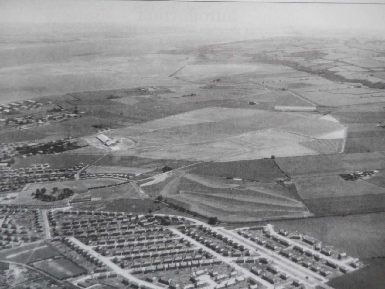
The inter-war years saw the demise of Abbotsgrange farm. In 1909 the Grangemouth Golf Club took two of its fields, and in 1938 it was one of six farms cleared to make way for the new Central Scotland Airport. The fields lost in 1909 were also part of the airport site – the golf club was recompensed with open land to the south of the park. A 1939 aerial photograph shows the new airport and the zig-zag terracing of the new golf course.
The Second World War Years
The Central Scotland Airport was closed to civilian traffic the same year. The Royal Air Force took the airfield over as a training base. During the Second World War, troops and airmen were housed in bell tents on the open parkland and allotments appeared on the site of the rose garden. There was still time for leisure pursuits – in 1944, an open air dance floor opened in the park!
Post-war
After the war, the airport was no longer needed for civil air traffic, the R.A.F. moved out, and the land was sold for industrial and residential development. By 1941 the golf course had been flattened and in 1953 this area was added to the park as an area of open grassland with football pitches, a sports pavilion and an indoor swimming pool. The rose garden was restored on the site of the war-time allotments. Tennis courts, a putting green and netball were added to the sports facilities and the cenotaph ornamental garden redesigned.
Looking to the Future
The park experienced a period of decline in the later years of the twentieth century but is now being re-invigorated and regenerated by the magnificent efforts of volunteers and local amenity societies. The park now benefits from the active work of many local volunteers as well as Heritage Lottery funding. Their work and ambitious future plans can be followed on the Zetland Park Regeneration Project and Falkirk Council websites.
By Iain Kirkman, Scottish Gardens and Landscape Heritage volunteer.