Did you know there were two Crownests on old maps of the Larbert and Stenhousemuir area? Do you know where the name Crownest comes from? Explore the history of the area through old maps and newspaper articles, and learn about prolific potatoes, missing canaries, and Mr. Crow…
Mapping Crownest
I was drawn to the unusual name of Crownest, as in Crownest Park and Crownest Loan, at the intersection of Stenhousemuir and Larbert. I decided to attempt some picking apart of the history of this small patch of Stirlingshire, starting with some map consultation.
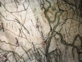
There are no fewer than two Crownests shown on Roy’s Military Survey of Scotland of 1747-1755 (2), the first standard topographic map of Scotland before Ordnance Survey mapping in the 19th Century. One Crownest is slightly to the north of the other, as shown below. Whether one was a farm and the other a group of houses, or whether it was marked twice in error (the lower Crownest is written in much fainter writing) I have not been able to find out.
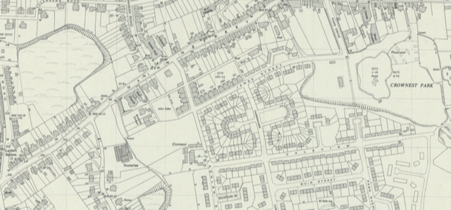
Moving forward two centuries, the name Crownest is still seen on maps, although now preceding “Farm” and “Park,” such as on this Ordnance Survey map from 1952 (3) below:
Crownest is mentioned at least as far back as 1510 in the Register of the Great Seal of Scotland, as explained by John Reid in his 2009 book The Place Names of Falkirk and East Stirlingshire (4). Reid suggests that “nest” may be an assimilation of “ness,” a promontory; there is a small headland leading down to the Carron River, where the lands of Crownest were located, according to Reid. In his 2019 Material for a Place Name Survey of East Stirlingshire (5), Reid lists different spellings found in the records for the name Crownest: “Crawnest, Croftness, Crowness.” A further definition of “crow’s nest” as “vantage point” may be another clue to its origin.
Crownest in the Falkirk Herald
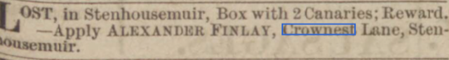
From maps, I turned to the Falkirk Herald in the British Newspaper Archives. From the 1890s, the street names of Crownest Lane and Crownest Road are mentioned in the Herald, in addition to Crownest Loan – the only street surviving to the present day with the name Crownest in it. The newspaper reveals snippets from the past relating to these long-gone streets, such as the missing box of canaries in 1895 (6):
Other stories from the Falkirk Herald include the 11-year old boy who was tragically run over by a horse and cart on Crownest Lane, in 1898. The horse had been “startled by a motor-car” and backed over the child, who had been on his way to Carron with food (7). The year 1904 saw one James Gordan, Labourer, of Crownest Lane, charged for “failing to provide sufficient elementary education” for his son. The boy, aged “between 13 to 14,” was, according to his father, “invariably sent to school, but… never went.” James Gordan added that “The boy was getting beyond the control of his mother,” and fined “7s 6d” or 3 days’ imprisonment (8).
Prolific Potatoes & Flooding
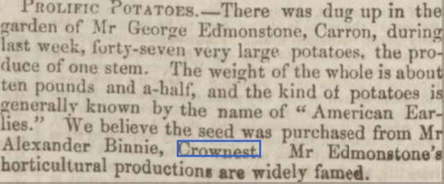
Moving on to Crownest Farm, on the Stenhouse Estate (9), the Stirling Observer in 1863 describes it as a “compact and tidy little farm”(10). In 1856, “prolific potatoes” were grown in a garden in nearby Carron, the seed for which was reportedly from Crownest Farm, as this excerpt from the Falkirk Herald claims (11):
The Park…and a baby show!
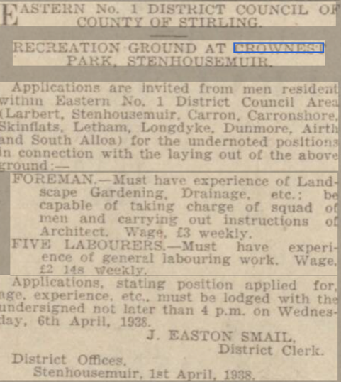
Turning eastwards to Crownest Park, the Ordnance Survey map published in 1921 shows more than one “Sand Pit” marked on the area that was to become the Park (17). Presumably these were used by the Carron Company in iron production. The first reference to the park that I could find in the Falkirk Herald comes in this advert from 1938 (18):
An advert for a “Deplenishment Sale” at Crownest Farm in 1921 illustrates the range of farming undertaken there at the time, the following being for sale: oats, Swedish turnips, two work geldings, two fillies, two mares, six Friesian cows, one Friesian heifer, three cross-bred cows, eight sows and fifteen young pigs, two boars, poultry and ducks… (12).
In 1928 the River Carron flooded with disastrous consequences for a flock of sheep “grazing in fields adjoining Crownest Farm.” “Strenuous efforts were made to save the animals, but the water rose so rapidly that salvage operations were practically out of the question. Fifty-three carcases were recovered… but many more must have been swept away” (13).
Crownest Farm appears on the Ordnance Survey map published in 1960 (14), but on the subsequent OS map, published 1967 (15), there is no sign of it. Nowadays, on maps, the area where the farm was once located is marked as Russell (Greengate) Park (16), a recreation area between two housing estates.
The following year, the Herald was extolling the park plans: “A new haven from the buzz of everyday life will be found by young and old alike in the Crownest Park…The District Council have to be complimented…in so adapting this piece of waste ground as to turn it into a place of beauty” (19).
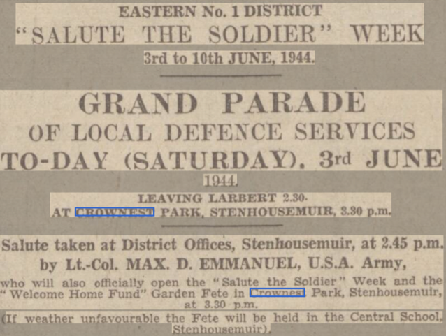
The park continued to be developed throughout the war. “Facilities for football” were available from 1944 (21). The park was used for parades and fund-raising events during the war, such as the “Welcome Home Fund Grand Fete” in June 1944 (22), whose attractions included a baby show, a rabbit show and, in sharp contrast to these, a “display of war weapons, tanks and German uniforms” (23)!
Further features continued to be added to the park up to the 1950s.The Herald expresses relief in 1949 that “the kiddies’ amusements which have been on order for about two years have been erected” (24).
Mr. Crow
Crownest is no longer regarded as a specific area within Larbert and Stenhousemuir as it was a couple of centuries ago, when at least three street names and a farm attested to its presence as a locality; or even centuries back when it was marked (twice) on Roy’s Survey. On maps, the name of Crownest lives on, not where the former Crownest Farm stood, but slightly to the east, at Crownest Park. However, as “the Lido” is used locally in preference to the name Crownest Park, in reality the sole surviving use of the name Crownest is in the street Crownest Loan.
So did the crow ever build its nest in this area? I haven’t yet mentioned Mr. Crow. In 1946, a ceremony marked the handing-over of keys to the first two houses built by Stirling County Council’s post-war house-building project at the Crownest site (as it was still then called). The ceremony was presided over by a Mr. Crow, from the Department of Health, Edinburgh (25). While the origin of the name Crownest might remain unclear, one thing is certain: over four hundred years after the first known reference to Crownest, there was at least one Mr. Crow in the business of building homes there.
By Cathy Hardingham, Great Place volunteer.