As Scotland’s Garden and Landscape Heritage (SGLH) Chairman I am very proud to present this story about Powfoulis Estate by Marilyn Scott, volunteer on the Glorious Gardens team assigned by SGLH to the recording of non-inventory designed landscapes and gardens in the Falkirk area. The Glorious Gardens project was launched in Falkirk in 2015 and was funded by Historic Environment Scotland. This is one of the 16 sites covered by SGLH in this area. A similar project was carried out in the Clyde and Avon Valley, and we are currently planning a third phase, which will focus on sites in East Lothian. For more details, please go to https://www.sglh.org.
Introducing Powfoulis Estate
The origin of the name Powfoulis according to the Dictionary of the Scots Language is: Old Scots “poll” (1375) which became “pow” (1481) from the Gaelic “poll” meaning a pit, a pond, mud, or mire. This is very common in placenames, and is cognate with “Puil,” meaning pool.
The Bruces of Powfoulis, a branch of the Bruce family of Auchenbowie, owned the estate from the beginning of the 16th to the beginning of the 18th century. In 1841, it belonged to a different Bruce family, James Bruce of Powfoulis.
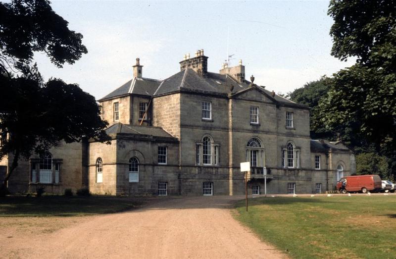
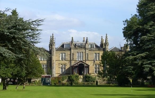
The estate is located on low lying land adjacent to the south bank of the Forth. The house is now independent of the estate. The original house was probably a tower house or small settlement with some trees built in the 16th century. A walled garden surrounded by trees, a lodge house, dovecot, pleasure garden, orchard, small area of parkland and a water tower were added over time. The existing house was built c.1820 in the Gothic style, possibly by James Bruce. Two wings were added in the mid-nineteenth century, when the stables and coachman’s house were built in Scottish baronial style to contrast with the house, which was further enhanced at the end of the 19th century by an elevated covered porch on the west front. Originally the main entrance may have been located on the east front when access was from the river side.
Historic Maps
Powfoulis (Pofoulls) appears on maps from the late 16th century onward.

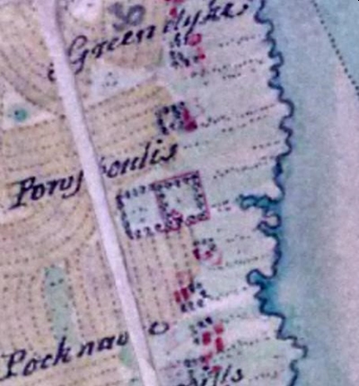
Apparently Powfoulis (Pofoulls) was a three-storey tower house with additional buildings and some trees. The parish record in the Old Statistical Account of 1791 refers to the Ancient Tower of Powfoulis. No trace of this building remains except on this map.
This image shows a walled garden at Powfoulis and another similar area enclosed by trees, adjacent to a salt marsh. There is a building in the south-west corner of the walled area. By the early 1800s the house appears as an important house or a castle. The saltmarsh seems to have been reclaimed. Dutch engineers worked on land reclamation in the area in the 17th century, but there is no evidence that such reclamation projects took place in the parish of Bothkennar.
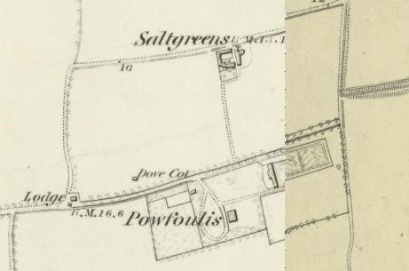
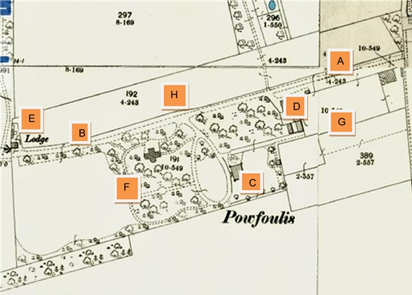
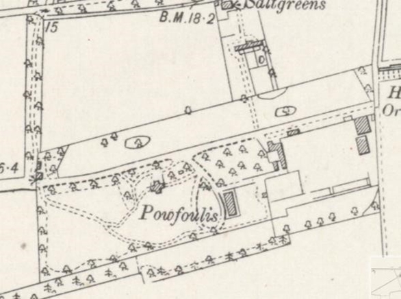
By the mid-1800s maps show the addition of a lodge and secondary building, dovecot (doo’cot), water tower north-west of the house, and kitchen garden behind the stables. At this stage there is no boundary wall extending south from the lodge gates. The oval carriage sweep is clearly marked.
The image below depicts turrets. There is a better idea of the planting layout with an orchard to the west of the house and mixed woodland to the north.
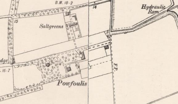
By the end of the century, a boundary wall extends south from the lodge gates, a cruciform building sits in the parkland west of the house, likely a conservatory to grow fruit and vegetables out of season and exotic plants, and there is a glasshouse in the walled kitchen garden. The hydraulic ram (used for field drainage) north-east of the rear gate is illustrated. The dovecot has gone. The orchard appears to have been replanted with hardwood trees and shrubs. It is also now crossed by a path aligned with the front entrance of the house.
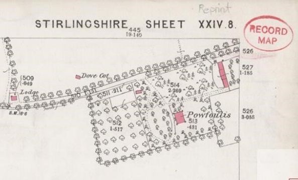
The changes continued, with redesigned paths, a second greenhouse alongside the first, and an additional small building directly opposite the house abutting the walled garden wall. The regular planting in the area in front of the stables suggests that this is now the orchard. Oval clumps of trees appear in the parkland to the north of the drive. Another structure has been added to the north-east exterior wall of the kitchen garden and one in the interior corner. The hardwood planting and shrubbery in front of the house have been replaced by a lawn.
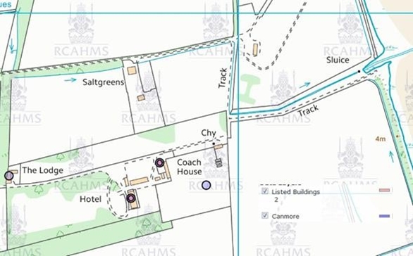
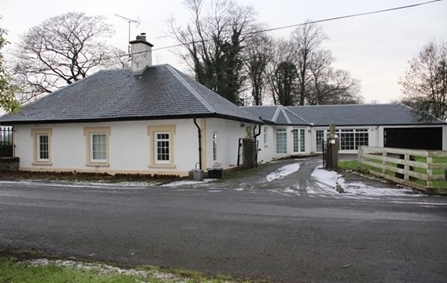
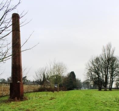
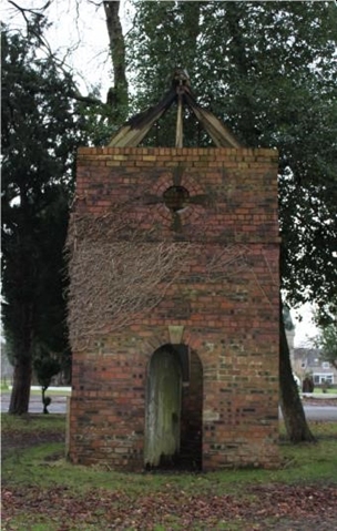
Today the lodge is an L-shaped listed building. You can see the hotel, coach house, coachman’s accommodation and walled garden. There is a Nissen hut and 1960s block of letting rooms on the north side of the main house. There are illustrations of a chimney (probably for the boiler used to heat the greenhouses) near the potting shed (or staff accommodation unit) and the small retaining walls or footings of earlier structures presumed to be greenhouses. The building is now an hotel.
Powfoulis Estate Timeline
14th Century
Edward, second son of Robert de Bruis of Clackmannan, married Agnes, one of William de Airth’s three daughters and thereby got possession of the lands of Airth, Powfoulis, Kinnaird, Stanehus, &c. in Stirlingshire ca. 1380 or 1390.
15th Century
1451 Alexander Bruce became the 1st of Stenhouse and Airth by Royal Charter of King James III.
16th Century
1512 Alexander’s grandson, Andrew Bruce, received land charters to Powfoulis Estates and became the 1st of Powfoulis.
Andrew, 1st of Powfoulis, married Janet daughter of Alexander Napier about 1531. They had three sons, Andrew, Archibald, Ninian. The Powfoulis estates remained in the hands of the Bruce Family for 10 generations.
Archibald Bruce, 2nd of Powfoulis, first married Jayne Gib and secondly c.1570 Marjorie (or Marion) Napier. They had two sons, James and Robert.
1550 James Bruce, 3rd of Powfoulis, married Margaret Rollox of Duncrab about 1608.
1512 Alexander’s grandson, Andrew Bruce, received land charters to Powfoulis Estates and became the 1st of Powfoulis.
Andrew, 1st of Powfoulis, married Janet, daughter of Alexander Napier, about 1531. They had three sons, Andrew, Archibald, Ninian. The Powfoulis estates remained in the hands of the Bruce Family for 10 generations.
Archibald Bruce, 2nd of Powfoulis, first married Jayne Gib and secondly c.1570 Marjorie (or Marion) Napier. They had two sons, James and Robert.
1550 James Bruce, 3rd of Powfoulis, married Margaret Rollox of Duncrab about 1608.
1580 Archibald Bruce, son of James and 4th of Powfoulis inherited the estate.
September 1599, Robert Bruce, son of Archibald, married Christian Arnot. They had a son, Archibald.
Archibald Bruce, 4th of Powfoulis, married Katherine Anderson c.1626.
Several stages of building and development occurred over the following century. The earlier house of Powfoulis was probably built c.1600 by Sir James Bruce the 3rd of Powfoulis and Dame Margaret Rollox of Duncrab whose initials appear on the Bruce Aisle of the Old Airth Church.
17th Century
James Bruce, 5th of Powfoulis, was killed c.1650 in the Battle of Dunbar against Oliver Cromwell. His son James, 6th of Powfoulis married Janet and had a son David.
James carried out further building work, evidenced by the gate posts at the North-East corner of the kitchen garden. The North post bears the date 1688, whilst the South post bears the Heraldic Arms of the Bruce Family and the word "Faithful," possibly the first part of the Bruce Motto "Faithful in Adversity.”
18th Century
1710 David Bruce, 7th of Powfoulis, married and had two sons.
1770 James succeeded his father David and became 8th of Powfoulis.
19th Century
In the New Statistical Account of Scotland, Revised April 1841, James Bruce of Powfoulis calls the house a modern building. The Gothic villa was built c.1820.
William Dawson purchased Powfoulis from James Bruce 10th of Powfoulis in 1855 and probably constructed the two wings in the mid-nineteenth century.
The stables and coachman’s house were built c.1860.
20th Century
The porch at the main entrance was built c.1900
1935 alterations to entrance lodge were undertaken for the trustees of William Dawson.
1941 the house had become a retirement home managed by the Church of Scotland.
1952 the Manor House and its immediate grounds were purchased from the Trust by the late James McAvoy who converted it into the present hotel.
1972 the hotel changed hands within the family and was run by Jack Barrie and his late wife Patricia until 1997 when Ann and Paul were brought into the partnership and currently run the hotel.
By Marilyn Scott, Scotland’s Garden and Landscape Heritage volunteer.